 |
 |
 |
Current Research |

|
|
|
Current Research |
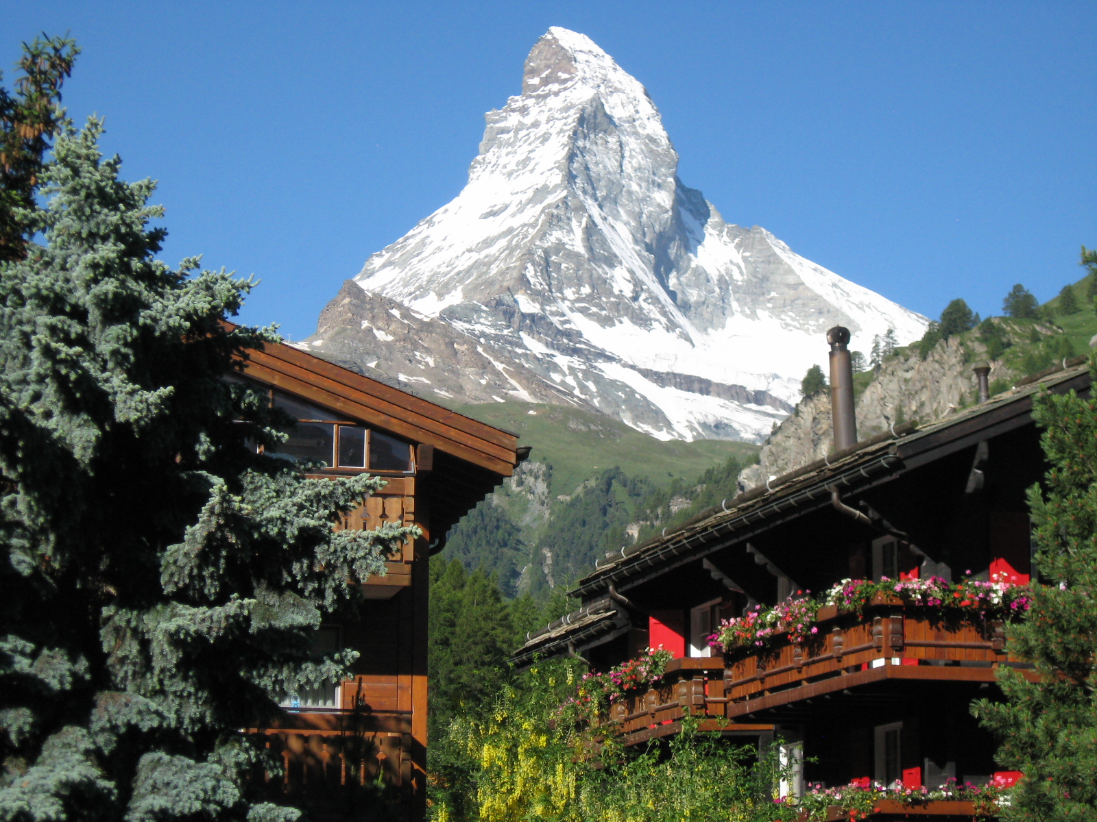
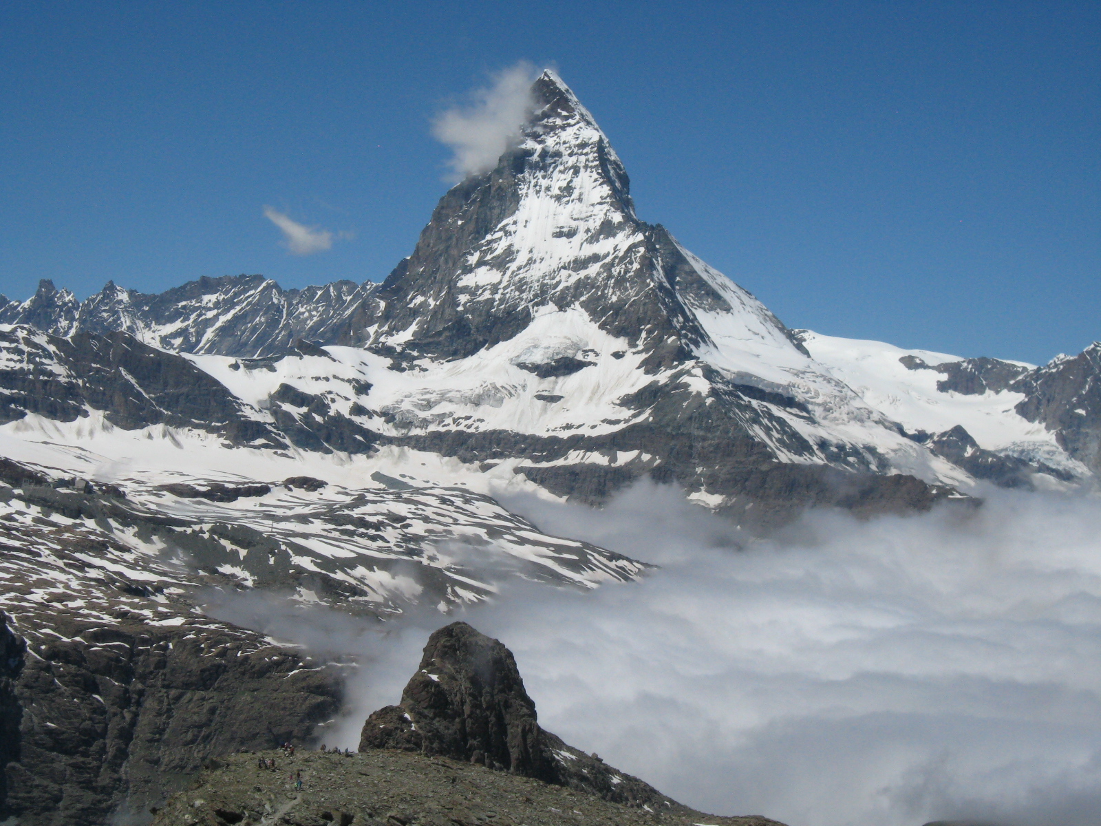
Matterhorn, Zermatt, Switzerland |
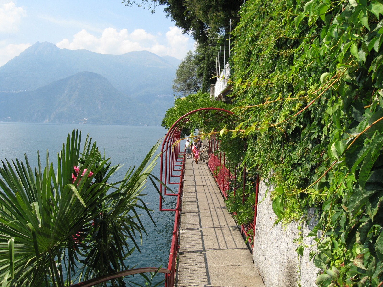
Varenna, Lake Como, Italy |

Sawyer Glacier, Alaska |
|
|
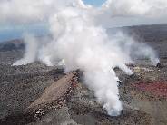 |
Hawaii |
 |
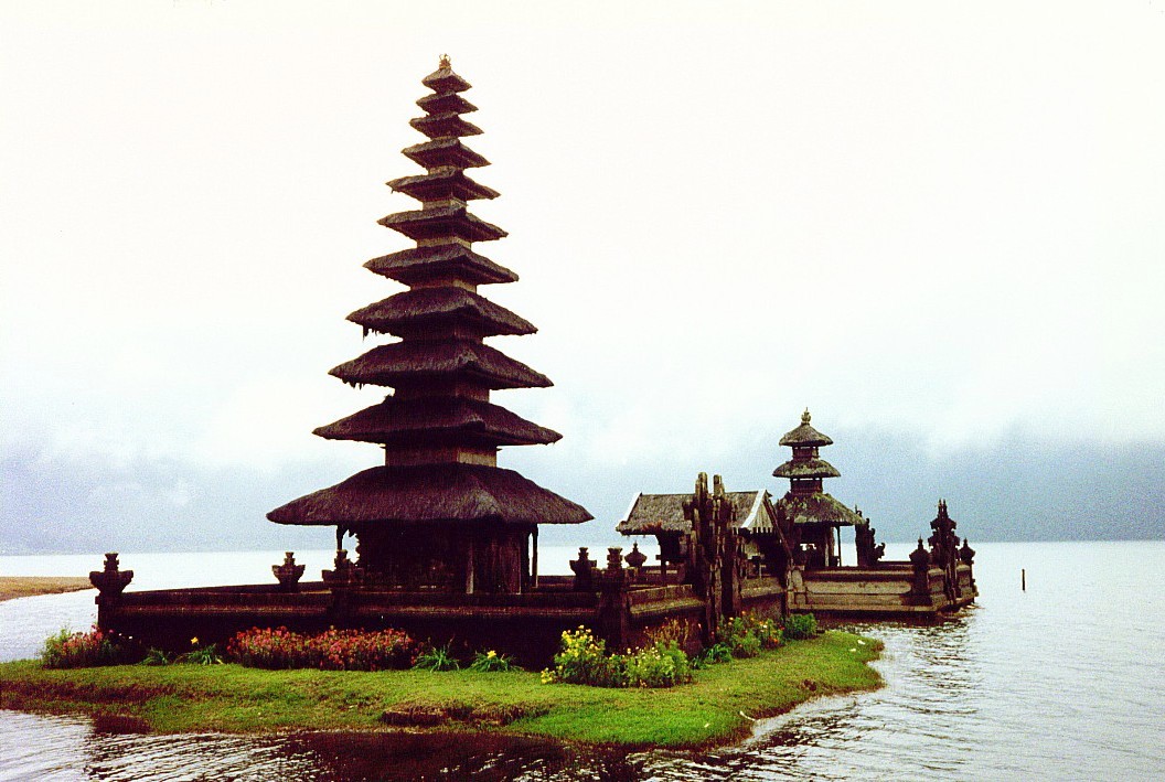
Temples, Processions, Rice Terraces |
 |
 |
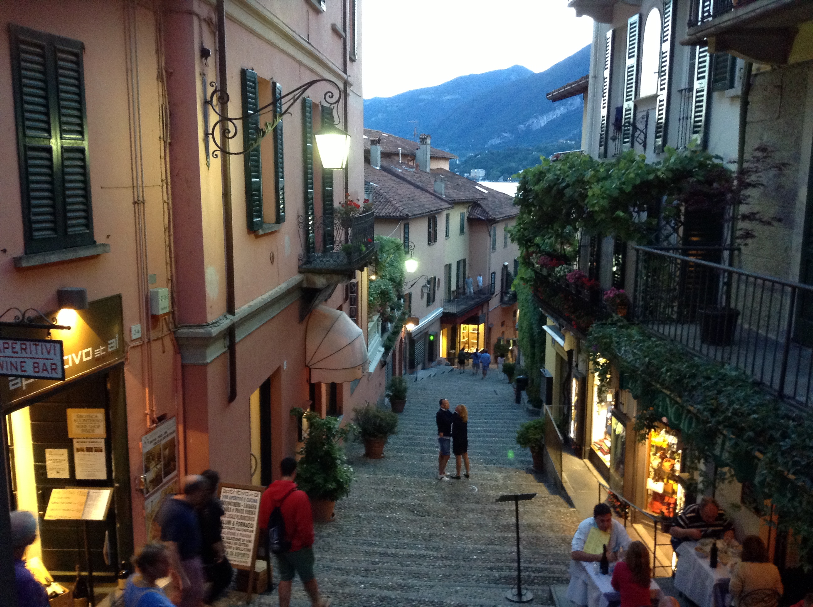
Bellagio, Lake Como, Italy
Salita Serbelloni, Heart of Bellagio
Colorado
"Purple Mountain Majesties"
Mesa Verde
TORAJALAND
Island of Sulawesi, Indonesia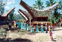
Cinque Terre, Italy A community of 5 towns built into the hillsides of the Ligurian coastline south of Genoa. A UNESCO World Heritage Site
Riomaggiore, the southernmost town.
Corniglia: accessible only by this train station or by a hiking trail that's currently closed.
Cinque Terre Coastline as seen from Monterosso, the nothernmost town.
Promenade along Monterosso's beach.
GENEVA, SWITZERLAND
QUICK TIME MOVIE: Catching the Beat on Lake Geneva.
(If the video doesn't play when you click the link, you can try opening the Quick Time Player and entering the following URL: http://psych.fullerton.edu/navarick/Geneva_Bobs_Buckets.mov)Lake Geneva's symbol, Jet D'Eau.
Maui, Hawaii
Baldwin Beach on Maui's "Windy" North Shore
Sirmione, Lake Garda, Italy A fairytale town at the tip of a narrow peninsula that you enter through a 13th century castle.
View of Sirmione from Castle Tower
Isola Bella, Lake Maggiore, Italy
Located just off of Stresa, this is one of three "Borromean Islands"owned by the Borromeo family since the 16th century.
View of Isola Bella from Stresa
QUICK TIME MOVIE: Bella Garden Panorama
(If the video doesn't play when you click the link, you can try opening the Quick Time Player and entering the following URL: http://psych.fullerton.edu/navarick/Bella_Garden_Panorama.mov)
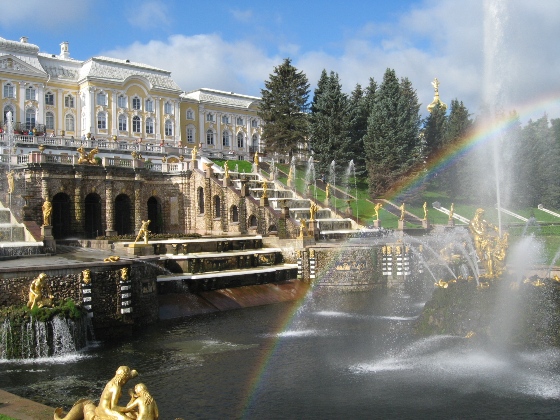
St. Petersburg, Russia
Peterhof Palace Fountains Under a Rainbow
Luzern, Switzerland Mount Pilatus Viewpoint View of Lake Luzern.
Enjoying Mount Pilatus Hiking trails, two hotels (circular building and another at opposite end of walkway), restaurants.
Cable Car to Mount Pilatus A surreal journey, gliding over villages and pastures, cowbells fading in and out.
Luzern Water Tower and Chapel Bridge Symbols of Luzern.
Luzern Historic Center Tourists and swans enjoying the ambience of a beautiful city.
Bourbaki Panorama Huge, 19th-century circular painting, with contemporary enhancements using realistic props, figures, and sound effects, that depicts key event in development of Swiss humanitarian tradition: French troops granted refuge after defeat by German army in 1871. They turn in their muskets as Swiss troops monitor the situation.
Bourbaki Panorama Contemporary Enhancements Figures in foreground blend in seemlessly with the painting. Together with the sounds, the enhancements make it easy to feel you're there.
Bavaria's Neuschwanstein Castle The Model for Disney's Castles
Switzerland's Bernina Express Spectacular route through the Alps from Chur, Switzerland to Tirano, Italy; listed by UNESCO as a World Heritage Site.
Barcelona's Montserrat Monastery One of Catalonia's greatest sights.
Italy: Milano and Lake Como Bellagio, Lake Como Promenade.
Bellagio A street in the heart of Bellagio.
Bellagio Landmark Metropole Hotel.
Bellagio Villa Melzi.
Bellagio Villa Melzi Giardini.
Bellagio Tempietto (chapel) at Villa Melzi.
Varenna, Lake Como Promenade.
Milano Close-up of the ornate spires and buttresses of the Duomo.
Milano Another view of the Duomo.
Milano Galleria Vittorio Emanuele II.
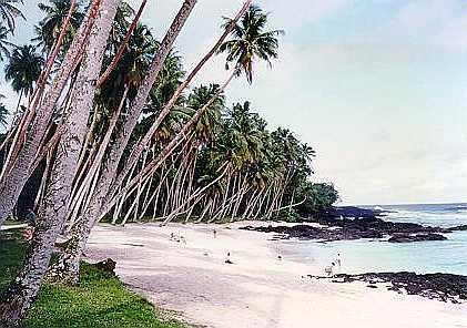
Island of Upolu, Samoa
"Return to Paradise" Beach
Norway and the Fjords Alesund Panorama of the city's three islands.
Hjorundfjord This fjord is located near Alesund.
Naeroyfjord Located near Flam, this fjord is listed as a UNESCO World Heritage Site.
Lysefjord Entrance This fjord is located near Stravanger. The bridge marks the entrance.
ROCK FORMATIONS Lysefjord Landmark: Pulpit Rock It's 2,000 feet high and a popular hiking destination.
Geirangerfjord: Face in the Cliff It has eyes, nose and a downturned mouth.
Mediterranean Medley Greece: Santorini View from cliff houses to cruise ships.
Greece: Porch of Caryatids, Erektheion, Acropolis
Venice: St. Mark's Square Panorama
Italy: Ancient Herculaneum Destroyed by Vesuvius in 79 AD; this was a shopping street.
Herculaneum Fresco Located in a room of a house; it shows Poseidon and his wife inside a seashell
Turkey: Ephesus Tourists on their way to Library of Celsus
Panama! Puente de las Americas
Sounds of Bangkok, Thailand: Take a Wild Ride in a "Tuk-Tuk" or Just Walk Around and Listen to the City
BROADWAY!
Click the Picture
and Go LIVE to
Times Square,
New York!
Douglas J. Navarick, Ph.D.,
ProfessorDepartment of Psychology
California State University, Fullerton
P.O. Box 6846
Fullerton, CA 92834-6846
Office phone: (657) 278-7040
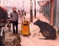
email: dnavarick@fullerton.eduON THE STREETS OF KATHMANDU, NEPAL Photo by Bob Kaplitz
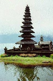
Left: Hindu Temple, Bali
FEATURES:
PowerPoint Replays Psychology 101 Introductory Psychology
Psychology 302 Learning and Memory
Read about my unique methods for combining digital and analog teaching technologies ...
Teaching at the
Cutting Edge

Featured Link: The Psychology of Abusive Behavior
"Heart of Darkness", PBS Online NewsHour, 5-11-04
Insights of psychologists into the processes underlying the abuses at Abu Ghraib prison, Iraq. Includes comments by social psychologist Philip G. Zimbardo in which he applies findings from his landmark 1971 study, the Stanford Prison Experiment. There are also links on this page that let you view the discussion in streaming video or listen in streaming audio.
MPEG Travel Movies & Photos-with-Sound
Movie Sample
Great Travel Destinations...from UNESCO! The United Nations Educational, Scientific and Cultural Organization publishes a list of WORLD HERITAGE SITES, places UNESCO considers to be so inspirational and universal in their appeal that they "belong to all the peoples of the world, irrespective of the territory on which they are located." The sites are arranged alphabetically by country, from Afghanistan to Zimbabwe, with photos, brief descriptions, and links. You can see photos of some of these places here on my site, such as Switzerland's Jungfrau-Aletsch-Bietschhorn region of the Alps; the historic center of Prague, Czech Republic; Indonesia's Borobudur Buddhist Temple Compounds; and the Colonial City of Santo Domingo, Dominican Republic.
Map and links to World Heritage Sites in the USA
Quick Pics
Click pic for full-screen photo (200 - 900 KB)
Dome of Florence,
Cattedrale di Santa Maria del Fiore
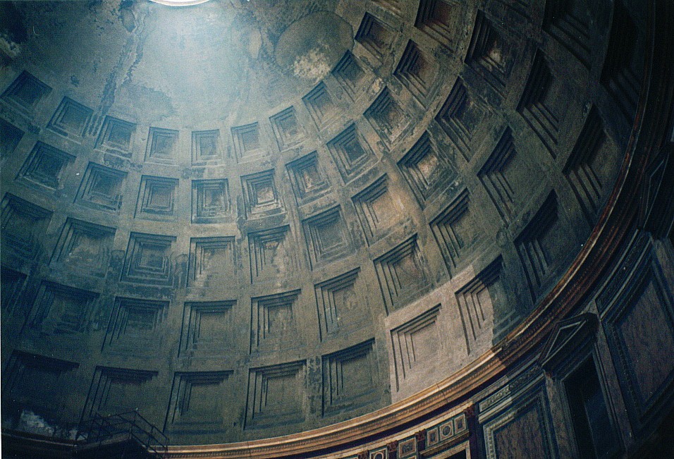
Pantheon, Rome
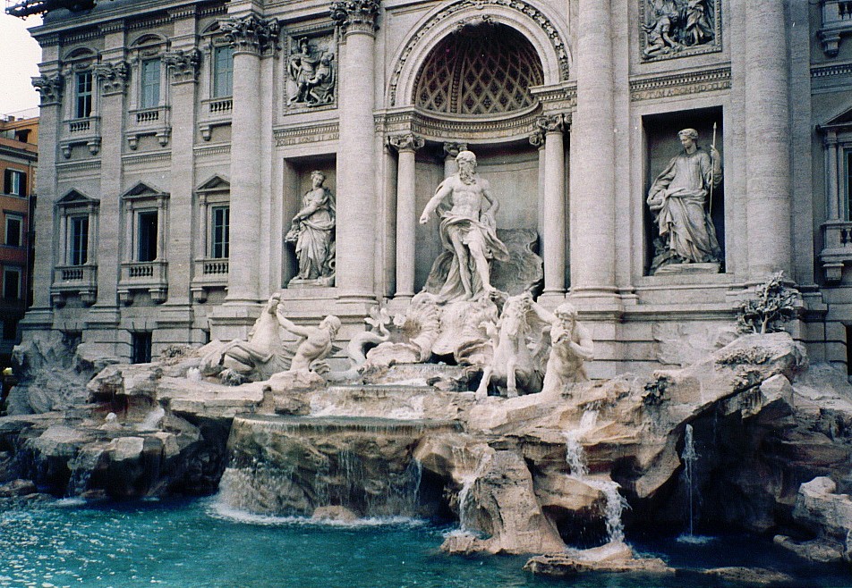
Trevi Fountain, Rome
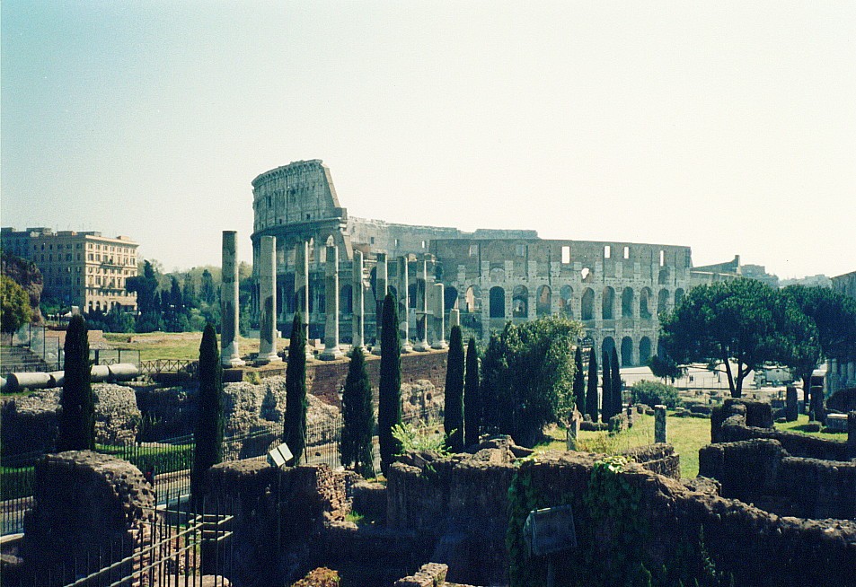
Colosseum, RomeMystical Temple, Bali
(Volcanic Lake Bratan)
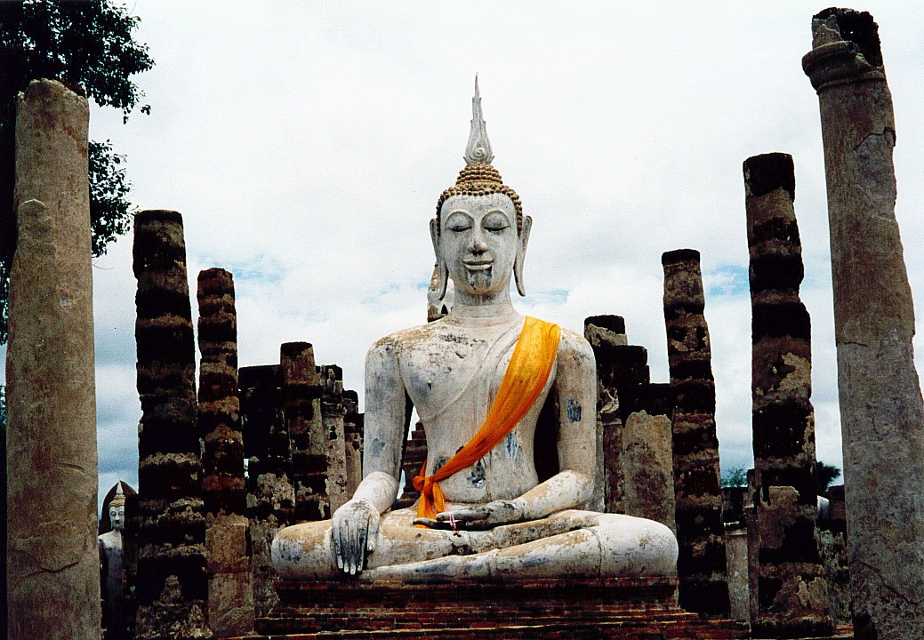
Ancient Buddha,
Sukhothai, ThailandBridge of Sighs, Venice Amazing Balinese
Temple EntranceBlack Sand Beach, Tahiti
"Butterfly" Dancer
Bandung, Java,
Indonesia
COLORADO "Purple Mountain Majesties"
In 1893, Katherine Lee Bates, an English teacher from Wellesley College in Massachusetts, was inspired to write the poem, "America the Beautiful," after a visit to the top of 14,110-foot high Pikes Peak at the eastern edge of the Colorado Rockies:
"Oh beautiful, for spacious skies, Bates' poem later became the lyrics of a national hymn. This photo, taken at Rocky Mountain National Park, shows the dense pine forests that cover the slopes below the majestic peaks.
For amber waves of grain,
For purple mountain majesties
Above the fruited plain!" ...
Atop Pikes Peak: Mountain View
In the foreground are the rails of a cog railway that visitors can take to the top as an alternative to driving. The train has gear wheels that mesh with the teeth in the center track and provide the traction when ascending the mountain and the breaking power when descending. The side tracks are only for balance.Atop Pikes Peak: "Above the Fruited Plain"
On a clear day you can see all the way to Kansas.
Mysteries of Mesa Verde Known as "Ancestral Puebloans," the people of Mesa Verde (Spanish for "green table") are perhaps best known for the villages they built under the cliffs from about 1190 to 1270 AD using advanced stone masonry techniques. These accomplishments represented the culmination of centuries of technological development following their arrival in about 550 AD.
Throughout their history, the Ancestral Puebloans lived at a "stone age" level of development because their tools were made of stone, wood, or animal bones rather than metal. In addition, they did not have the advantages of the wheel, beasts of burden, or horses, and the only domesticated animals they possessed were dogs and turkeys. Despite these formidable obstacles and a harsh climate, the Ancestral Puebloans prospered through ingenuity and perseverance. In addition to stone masonry, they achieved high levels of sophistication in farming and irrigation techniques, and they were also accomplished at basketry, weaving, pottery and tool- and jewelry-making.
They left no written record so much of their history and culture remains a mystery. For example, why did they move from their mesa-top villages? Possible reasons were protection from the elements (e.g., most were built facing away from the prevailing winds), easier water collection (water percolated down through the sandstone and formed pools on shale surfaces), and food storage above ground (protection from animals).
Probably the biggest mystery is why they left their homes and moved away from Mesa Verde just a few decades after completing the cliff dwellings. Although the migration was probably clan-by-clan over a period of years, by 1300 Mesa Verde was deserted. Contributing factors were a quarter-century drought and land depletion. However, there were also signs of increasing conflict and defensiveness. Although most cliff dwellings were easy to spot from across the canyon, and were built to protect from the wind, one of the last to be built, called "Balcony House", was tucked away almost invisibly, gave less protection from the wind, and had access restricted through a narrow tunnel, something like a fortress. One of their last structures, the Sun Temple, was built of the smoothest, most finely crafted stones and afforded a magnificent view of the canyons, a mighty offering to the deity, but it was left unfinished. This seeming final appeal to remain in Mesa Verde failed to change the dynamics of the migration. The Ancestral Puebloans moved south in search of opportunities for a better life. They joined kin already living in the areas of Arizona and New Mexico, and today some tribes such as the Hopi and Zuni may include descendents of the Mesa Verde cliff dwellers.
Mesa Verde National Park is a UNESCO World Heritage Site and it celebrated its Centennial in 2006.
Cliff Palace
This is the largest of the cliff communities. It is thought to have served as an administrative center and may have had the function of storing and redistributing surplus grain. In the lower right of the photo a Park Ranger discusses the site with a group of visitors.Spruce Tree House
This is the third largest cliff dwelling in Mesa Verde and one of the best preserved. The circular structure is a "kiva" ceremonial room. These rooms were partly below ground and had roofs, most of which are gone. The T-shaped openings in the buildings are doorways. They may been designed to reduce heat loss, allowing just enough space for people to carry items in and out.Spruce Tree House: Kiva with Roof
Visitors can enter a kiva with a restored roof by climbing down a ladder. Note how the tops of the buildings follow the contours of the cliff. One reason for building under cliffs may have been to avoid having to build roofs for some of the structures.Square Tower House
This is the tallest structure at Mesa Verde. The Tower is nestled up against the back of the cliff and follows its contours, showing how the cliff was sometimes used to form a part of the building.Long House
This is Mesa Verde's second largest cliff dwelling. The blackening on the underside of the cliff is from soot produced by fires that were made for heating and cooking.The View from Sun Temple
As previously mentioned, Sun Temple was a great, unfinished structure that may have been intended as an appeal for better living conditions at Mesa Verde so that the area would not have to be abandoned.
PANAMA! In Panama you can go from the Pacific Ocean (Panama City) to the Atlantic (Colon) in 55 minutes by express train in the morning, explore the Caribbean coastline, rainforests, and towns and return by train in the afternoon or perhaps take a more leisurely ride on the 2-lane, trans-isthmus highway for views of daily life and the magnificent countryside. Amazingly unique and exotic, Panama has been at the crossroads of world trade, intrigue, and conflict since it was discovered by Columbus in 1501-02. It is the "bridge of the Americas" geographically, economically, and culturally (for example, Spanish is the official language but English is widely spoken and the US dollar is used as the currency). In 2,000, Panama acquired sovereignty over the Canal and the former, 10-mile wide Canal Zone as the result of a treaty signed with the US in 1977. Panamians now host tourists in areas where a few years ago the Panamanians themselves were not allowed to go. New hotels and shops are appearing, especially along the Amador causeway at the Pacific entrance to the Canal. It was built using soil that was dug out for the Canal and it links several islands previously used to store ammunition for the Canal's defense. The photos, below, show scenes from the three sets of Locks that are used to raise and lower ships in steps as they proceed across the isthmus (Gatun, Pedro Miguel, Miraflores), rain forests along the Canal, the Panama Canal Railway, historic sites in Panama City, and a fort at Portobelo on the Atlantic, an area that has been designated a UNESCO World Heritage Site.
Gatun Locks
On the Atlantic side, the Gatun Locks consist of 3 chambers that progressively raise or lower ships 26 meters (85 feet). The chambers are like bathtubs that either fill with water or release it into the next chamber through underground culverts. When the water levels are equal, the steel gates open and the ship proceeds. The locks here and elsewhere are 110 feet wide, and ships are required to be no wider that 106 feet (many ships are built this wide so they can pass through the Canal). Ships move under their own power but are kept precisely on course by cables attached to electric steering locomotives on both sides of the lock. The ship shown here, heading towards the Atlantic, barely fits through the locks and seems to have just an inch or two of clearance on each side.Gatun Gate and Historic Building
The gate is closed and a walkway leads to an historic building showing the date of completion of the Gatun Locks, 1913. The Canal opened the next year.Ship Entering Pedro Miguel Lock
Pedro Miguel is a single-chamber lock that lifts or lowers ships 9.5 meters (31 feet). The ship shown is the maximum size for the Canal (called a"Panamax" vessel) and it is heading toward the Pacific. The channel behind the ship is the Guillard (Culebra) Cut, and the Centennial Bridge over this channel can be seen, along with another huge freighter waiting for its turn to enter the Lock.Miraflores Locks
Heading towards the Pacific from the Pedro Miguel Lock, a ship crosses artificial Miraflores Lake and then enters the 2-chamber, Miraflores lock system, which will lower the ship 16.5 meters (54 feet). This photo was taken from inside the first chamber with the gates closed and the water level at the height of the lake. The water level in the next chamber is much lower. Water will be allowed to flow from the first to the second chamber, and when the levels are equal, the gates will automatically open and allow the ship to enter the second chamber. Amazing sidelight: all of the water in the canal up to this second chamber is fresh water from a system of dammed-up rivers and artificial lakes. When the second chamber opens, any fresh-water fish within the chamber will be killed or stunned by the salinity of the next waterway, which flows into the Pacific with no further locks. Birds have learned to associate the bubbling water at this location with the presence of easily caught fish, and they gather overhead as the gates open.New Soldiers of Portobelo Fortress
On the Atlantic side, north of Colon, is Portobelo Bay and a system of fortresses that the Spanish used to protect shipments of gold and silver on their way from Peru to Spain. The forts were often attacked by pirates. This is San Jeronimo Fort. Here, an invasion of tourists brings out a brigade of Portobelo's newest defenders. They're eagerly running past a battery of cannons aimed at the bay. In the background is the customhouse (built 1630) that was used to store gold, silver, and merchandise being used for trade with the Indians. To the left can be seen the San Felipe De Portobelo Church, which houses the "Black Christ" statue that is venerated throughout Panama.Ready for Battle
The defenders take up positions on the ramparts.Gamboa Rainforest Aerial Tram
A unique and convenient way to experience the rainforest alongside the Canal is by means of a ski-lift style aerial tram operated by the Gamboa Rainforest Resort located within the Soberania National Park about halfway between Panama City and Colon. Accompanied by a guide, you glide silently up through the trees and over the canopy to an observation tower that provides commanding views of the Chagres River (main source of water for the Canal), Gatun Lake, and the Guillard Cut.Rainforest Art
Seen from above, the canopy sometimes has the appearance of abstract art. This is another Gamboa "canvas".Panama Canal Railway
The Panama Railroad began operating across the isthmus in 1855, long before there was a canal (opened in 1914). It was built to help gold prospectors from the US east coast get to California during gold rush days. This was considered a safer route than crossing the western frontier and risking attacks by Indians. Later, the route was changed slightly and the railway was used for the construction of the Canal. Today, it makes a single roundtrip on weekdays carrying commuters and tourists (in separate cars). It leaves Panama City at 7:15 AM and returns from Colon at 4:30 PM. This photo was taken in the luxurious observation car designed for tourists. Two Railway employees are going through the car. On the lower floor (ahead of them) is a snack bar, and behind them is an open-air observation platform, an exciting way to ride the train as it flies through the rainforest (visible through the dome).Crossing the Chagres River
The train crosses an historic bridge over the Chagres River (the source of water for the Canal) on its way to Colon. The dome of the observation car can be seen in the distance.Bishop's House in Panama La Vieja
Panama City was founded in 1519 and destroyed in 1671 after an attack by the pirate, Henry Morgan. This area is known as Old Panama. The city was reestablished a couple of years later in a safer location and is known as Colonial Panama. With ongoing renovations, "Casco Viejo" is fast becoming a fashionable district of today's city of highrises, which is located between its historic predecessors. This photo shows the best preserved, large structure in Old Panama, the Bishop's House (Casa del Obispo). A drawing on the sign shows the original structure, quite a contrast with what remains.
PELE'S HAWAII Pele is Hawaii's goddess of volcanoes and according to tradition she resides in the Halema'uma'u crater of Kilauea Volcano on the Big Island. Kilauea is located in the southeast corner of the island inside the Hawaii Volcanoes National Park and is Hawaii's most active volcano, specifically, the area around Pu'u O'o crater. Lava flows from this area through underground tubes to the sea and creates new land. The photos below show Pu'u O'o, the lava field that extends to the sea (Kupaianaha Lava Shield), and the formation of a black sand beach from this field. There are also photos of Kilauea Iki crater, which erupted in 1959 and created a lava lake, and Halema'uma'u crater, Pele's home.
Pu'u O'o Vista
As the helicopter approaches, smoke from multiple vents rises to meet the clouds. The tiny speck in the left-center area of the photo is another helicopter.Pu'u O'o Crater
A view from over the crater showing surrounding field.Inside Pu'u O'o Crater
A close-up of the interior. A stream of red-orange lava can be seen.Kupaianaha Lava Shield
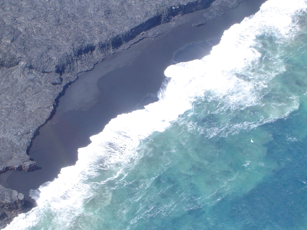
Smoke rises from the sea as lava enters through underground tubes and forms new land. A helicopter appears as a speck in the top-center area of the photo and conveys the vastness of the lava field.Formation of Black Sand Beach
Textured lava cliffs overlook beach carved out and smoothed by waves.Kilauea Iki Crater Overlook
Kilauea Iki Crater is located inside Kilauea's huge Caldera (a drive around the rim is 11 miles). Iki erupted in 1959 with spectacular fountains of lava and created a lava lake that has since cooled and solidified enough to walk on. This view from an overlook 400 feet above the surface shows a portion of the crater and some people walking on a path extending out from the forest.Inside Kilauea Iki
This photo was taken from the same path shown from above in the previous photo. Plants rise from some cracks in the lava. Steam rising from other cracks shows that the interior is still hot.Pele's Home, Halema'uma'u Crater
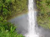
This is a sacred site in Hawaiian tradition.Akaka Falls
Akaka Falls, located in a rain forest near Hilo, symbolizes the beauty of Hawaii.
AMAZING Maui, Hawaii Heavenly Beach Scene
View of coastline and western mountains from Baldwin Park, Hana Highway.Sacred Ioa Valley
The landmark Ioa Needle in the western mountains of extinct Halemahina Volcano.
Dormant Haleakala is the larger of the two volcanoes that created Maui. Its last eruption may have been as late as 1790. The crater summit is 10,023 ft above sea level and the volcano extends another 18,000 ft below the sea, which makes this one of the tallest mountains in the world (Mount Everest = 29,035 ft).
Three of Hawaii-Big Island's five volcanoes can be seen in this photo. In front, partially covered by clouds, is Hualalai (8,269 feet above sea level) on the dry Kona coast (west side of island). Hualalai is categorized as active, its most recent eruption being 1800-01. Behind it is dormant Mauna Kea (13,796 ft); its last eruption was 4,500 years ago. Mauna Kea is the highest mountain in the Hawaiian islands, and if measured from the ocean floor it is the highest mountain in the world (31,996 feet according to one source). To the right and behind Mauna Kea is Mauna Loa (13,677 ft), the largest volcano in the world in terms of total mass. It last erupted in 1984, sending lava to within 4 miles of Hilo, the seat of county government, located on the lush (and rainy) east coast. On the other side of Mauna Loa is Kilauea, which has been erupting since 1983. Daily eruption updates are provided by the U.S. Geological Survey's Hawaiian Volcano Observatory.Haleakala Lava
A helicopter view of the lava on the other side of the volcano.Inside the Copter
Passenger's view as Blue Hawaiian Eco-Star gets next to crater.Sunset at Kihei
Strolling and swimming as the tide comes in at Kihei's Kamaole I Beach, South Maui.Banyan Tree, Lahaina Courthouse Square
It resembles an octopus, with over a dozen trunks spread out over an area of 200 ft. It was 8 ft high when it was planted in 1873; now it's 50 ft. Lahaina was once the capital of the Hawaiian Kingdom and it was a major whaling port in the 1800s. MPEG MOVIE (1.2 MB) Hammerhead Shark
A scalloped hammerhead shark at Maui Ocean Center, Ma'alaea. With their flat, wide heads, they look like hammers when viewed from above. Their eyes are where you might expect their ears to be. The shape of the head may improve sensory abilities, such as picking up electromagnetic signals from prey and navigational landmarks. The head has receptors on its underside and it sways back and forth as they swim, which may increase the area being scanned.
 | |
 |
While you're in Bangkok, you may want to check out a copy of today's newspaper, the Bangkok Post ; it really captures the excitement and dynamism of this magical city. The Letters-to-the-Editor section," Postbag," is a great way to find out what people are thinking.Albums, Webcams, MP3, Streaming Audio
VISIT: The Island of Bali, Indonesia You will see beautifully contoured rice terraces, colorful religious processions, and exotic temples.
VISIT: Samoa in the South Pacific Touring this Polynesian country, you will see traditional thatched houses with turtle-shaped roofs mounted on poles; idyllic, palm-fringed beaches; and a bustling market in the capital, Apia. You can also visit the mountain-top resting place of Robert Louis Stevenson ("Treasure Island," "Dr. Jekyll and Mr. Hyde"). Explore Samoan Life and History
GO LIVE TO: Schilthorn Mountain, Switzerland You're at the entrance to a circular, revolving restaurant at the top of this 2,970-meter mountain, with a spectacular view of the surrounding peaks. There's a choice of three camera angles. The picture updates every minute from 7:00 AM to 5:00 PM Swiss time (10:00 PM to 8:00 AM PST). I've got some dramatic photos of this area. To see the cable car approach the mountain, click cable car. For the complete photo album, click album.
VISIT: Venice, Italy, where you can watch gondolas and water buses go by on the Grand Canal; see some of the countless architectural treasures; explore a maze of narrow, interior canals; and relax at an outdoor cafe next to the Rialto Bridge. See and Learn More About Venice
PhotoAnimation: "The Magic of Venice"
A photo of the Grand Canal becomes an interactive movie set to music! You can develop the story by clicking on icons to add or remove characters from the scene. I created this show by downloading "animated gifs" from clip-art sites (as well as some "midi" music) and adding the images to my photo using layering techniques.
GO LIVE TO: Pike's Peak in the Colorado Rockies At 14,110 feet, this lofty place inspired the writing of a national hymn: "America the Beautiful." You can experience the "purple mountains' majesty" as you sit 15 miles away in Colorado Springs and watch a color picture that changes about twice a minute. The best viewing times, including sunrises and sunsets, are provided at the website. There is no picture at night.
VISIT: Torajaland on the Island of Sulawesi, Indonesia This remote land, located in the mountains of an island once called "Celebes," combines magnificent scenery with macabre cultural practices. You knowyou are in Torajaland when you see the houses shaped like boats. Torajans believe that their ancestors came from some spiritual realm in similar boats. Returning to this realm through death is a cherished rite of passage. The highlight of any tour of Torajaland is to attend a funeral festival, and you will see one here. Then things turn ghostly as we visit the cemeteries. Please be advised: What you see at this point could be unsettling. Crypts are carved into the sides of mountains, and statues of the dead stand on balconies in front of the crypts gazing out over the lovely landscape. They're all over the place and it's creepy! I'll tell you before the crypt tour begins in case you would prefer to skip it. Torajan Life and Tribal Art
VISIT: Gaudí's Barcelona The fantastical spires of his unfinished cathedral, La Sagrada Família, are the city's symbol. Antoni Gaudí (1852-1926) was a forerunner of architectural modernism, but his many creations are in a class by themselves. On this tour you will see the spires from the inside as well as out; view an apartment house shaped like the waves of the Mediterranean, complete with seaweed (it's on the balconies); see chimneys that look like knights in armor and abstract art; and relax at an outdoor cafe in a lush, tropical setting that is part real, part fantasy. Gaudí's creations express the spirit of Barcelona: bold, vibrant, and inspired. Learn More About Gaudi and Barcelona
GO LIVE TO: Niagara Falls, New York You can see the mist rising from the falls with this camera that updates every few seconds. Then you can go right to the water's edge by clicking: Up Close These may be the most spectacular, live webcam sights anywhere.
Traditional Thai Music
A virtuoso performance on the Thai xylophone, called a Ranad-ek, formatted in MP3. It was recorded at Bangkok's Erawan shrine, a small, fenced courtyard next to the Grand Hyatt Erawan Hotel that displays a statue of the Hindu god, Shiva. Many Thais believe that this statue can grant wishes and bring good luck. They pay the musicians and a resident troupe of dancers to stage performances next to the statue. MPEG movies of the dancers are presented on my movie page.
SOUND-PHOTOS: Take a Wild Tuk-Tuk Ride In Bangkok, Thailand a tuk-tuk (pronounced "toook-toook") is an open air, 3-wheeled, motorized pedicab that makes a distinctive tuk-tuk sound when it idles. When you get to Bangkok, just click the link for a 5-minute thrill ride. Our daring driver rides on sidewalks as well as roads and even speeds the wrong way down a narrow, one-way street. You'll need RealPlayer. You can download the latest version for free by clicking RealPlayer .
HEAR IT NOW! A Day in Bangkok Take the bus from your hotel to Siam Center, a major shopping mall in the center of town.When you arrive, have a conversation with a Thai man on the street. Listen to the vendors and shoppers at the mall, and ask about a
language tape that's playing; Thai people use it to learn English. Then it's on to the Lemon Grass Restaurant for a gourmet lunch. Each link, below, plays a short segment through the RealAudio Player. If you don't already have it, you can download it for free at RealPlayer.
On the BusWhat's it like to ride in a bus where the engine is inside under a thin, metal hood next to the driver? It roars and rattles like crazy, and you're sitting right next to it! Segment length: 1 minute, 30 seconds.Conversation with a Thai Outside the Siam Center Shopping Mall, we talk to a man about the weather and his impressions of America. Segment length: 2 minutes, 7 seconds.
Browsing at the Mall What does the Thai language sound like? We stop at a booth that sells Thai-English language tapes and listen to a sample. Segment length: 2 minutes, 16 seconds.
Pop Music, Thai-Style The sounds are delightful and always changing as we pass by the stores and booths. Here is a pleasant little melody that may stay with you after we leave. Segment length: 55 seconds.
Lunch at the Lemon Grass Restaurant: The Menu We come in off a busy, noisy street and are immediately soothed by the quiet, elegant surroundings. As I read items from the menu, I give the prices in "Baht", the Thai currency. At the time of this recording, 1 Baht = U.S. $.04 (now it's less than $.03), so a 50-Baht item would cost $2.00. Segment length: 1 minute, 1 second.
Let's Eat! It's "unbelievably delicious!" Just listening to it makes me want to go back for more. Segment length: 2 minutes, 25 seconds.
 VISIT: Seoul, Korea where you can see an astonishing mixture of modern high-rises, centuries-old palaces with secret gardens, and teeming street markets that provide a stage for some very unusual entertainment. Explore Life in Korea
 VISIT: Borobudur Buddhist Monument, Java, Indonesia Built
in about A.D. 800, it is the largest Buddhist monument in the world, a virtual mountain of exquisite stone relief carvings depicting scenes from religious stories. It was used by priests to teach devotees the fundamentals of Buddhist moral philosphy. You climb the mountain by walking through high-walled corridors displaying the scenes. That's about 3 miles of walking if you don't take shortcuts. When you finally reach the top, you see out over a vast plain. This symbolizes spiritual enlightment: Your vision has been expanded.
The photos in this album include closeups of the carvings as well as a sampling of the magnificent vistas.
VISIT: Borobudur Buddhist Monument, Java, Indonesia Built
in about A.D. 800, it is the largest Buddhist monument in the world, a virtual mountain of exquisite stone relief carvings depicting scenes from religious stories. It was used by priests to teach devotees the fundamentals of Buddhist moral philosphy. You climb the mountain by walking through high-walled corridors displaying the scenes. That's about 3 miles of walking if you don't take shortcuts. When you finally reach the top, you see out over a vast plain. This symbolizes spiritual enlightment: Your vision has been expanded.
The photos in this album include closeups of the carvings as well as a sampling of the magnificent vistas.
1. Italy's Amalfi Coast
2. Ancient City of Pompeii
3. Switzerland's Spectacular Jungfrau Region
4. Amazing American Samoa
Visits Since October 8, 2002:
All photos are copyright © 1999 - 2017 by Douglas J. Navarick. For permission to republish, please contact: dnavarick@fullerton.edu
Doug Navarick's PhotoAnimations |
|
|
 |
| dnavarick@fullerton.edu |
This page was last revised on January 3, 2017,